When it comes to planning trips, we look for the unusual. We have our criteria of picturesque, culturalistic, adventurous and more. In this case, we looked around and found a “Rails West” trip. It included the canyon lands and monuments (both of which we wanted to shoot), river rafting, and rides on some narrow gauge trains through the mountains to historic old towns. And since this was a tour, the itinerary was somewhat rigid and pre-planned. Don’t get me wrong, structure is fine as long as there is a balance of free time with sights to see or activities to do.
Once chosen, we brought this up to family and my parents thought it sounded like fun. They enjoyed our planning of Hawaii and this one had many things they were excited to see. We decided to arrive a day early to acclimate and tour Salt Lake City.
Welcome to our Rails West Trip
We arrived and knew there were things we wanted to see. Mom and dad had never been on a tour before. We told them that the itinerary would be rigorous, yet fair. We would have to be up early and have our luggage ready to go. We got into Salt Lake City in time to tour the Mormon tabernacle. Dad would have liked to have seen more and had some time in the genealogy library, but it was not open.
The beauty of the church, both inside and outside rivaled some of the European churches and cathedrals. While not as ornate, the shear size and architecture was impressive. And like the European churches, this one made you feel small.
After spending the day touring the city, we had met the Rails West tour group for dinner and orientation and then retired for the night.
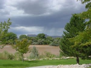
Storm brewing over the Green River
The next morning, we were up and on the bus This tour was similar to our European tour. We headed to the Green River for our first stop, the John Wesley Powell River History Museum.
John Wesley “Wes” Powell (March 24, 1834 – September 23, 1902) was a U.S. soldier, geologist, explorer of the American West, professor at Illinois Wesleyan University, and director of major scientific and cultural institutions. He is famous for the 1869 Powell Geographic Expedition, a three-month river trip down the Green and Colorado rivers, including the first official U.S. government-sponsored passage through the Grand Canyon.
 Powell served as second director of the U.S. Geological Survey (1881–1894) and proposed, for development of the arid West, policies that were prescient for his accurate evaluation of conditions. He became the first director of the Bureau of Ethnology at the Smithsonian Institution during his service as director of the U.S. Geological Survey, where he supported linguistic and sociological research and publications.
This is a definite stopping point. The museum has a wide variety of exhibits, highlighting discoveries along the Green River. They explained the who’s and why’s of exploring the rivers and the canyons and its natural wonders.
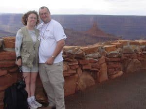
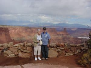
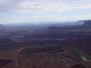 From here, we journey to Dead Horse Point State Park. Dead Horse Point State Park is a state park of Utah in the United States, featuring a dramatic overlook of the Colorado River and Canyonlands National Park. The park covers 5,362 acres (2,170 ha) of high desert at an altitude of 5,900 feet (1,800 m).
The landscape was awesome and remind both Teresa and I of the Grand Caynon. Mom and dad had never been to the Grand Canyon. The closest mom and been was flying over it (on our way to visit my dad when he was on R&R leave in Hawaii years ago. The park is so named because of its use as a natural corral by cowboys in the 19th century, where horses often died of exposure.
A few hours later, we were on the bus heading to Moab for the night. We were cut loose to find dinner and we discovered a local restaurant with local flavor.
Moab has so much around it, the Canyon lands, Arches National Park, the Colorado and Green rivers… for naturalists, for photographers, for those seeking adventure both big and small, this is a good place to call your base camp and we are calling it home for two nights.
Arches National Park & Colorado River
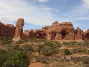
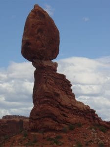 After breakfast, we headed out to Arches National Park. From the bus, we saw many different formations. We learned that they were formed by water and then wind. Teresa and I could have spent days, if not weeks out here photographing. Seems like we always find places like that, like Versailles.
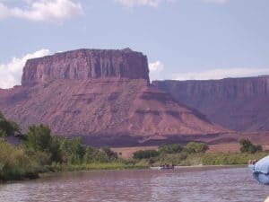 After the Arches National Park, we were taken to the a rafting company for a White Water Rafting excursion on the mighty Colorado river. Now my folks have been adventurous before. They had done the Maui Downhill, biking down from the summit of a volcano to the beach. I knew my dad liked water and did not mind canoeing as we had done this every summer growing up since we moved to Indiana. We gathered our gear, life vests and paddles and got into our assigned boat with several other people. Our guide was a young lady and she took us out. Just a short distance down river, we hit our first rapids. It was thrilling. No, they were not Class IV (4) or even class III, they were class I and II at best. Still, we were white water rafting on the mighty Colorado.
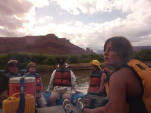
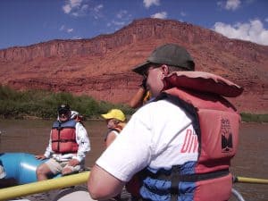 After several rapids our guide, who had been steering and also pointing out features along the way, paused in a rather calm area. She looked around at the group and asked, “Who wants to give this a try?” I raised my hand and she handed me her oars, then stood up and stepped of the raft, into the water, and wished us “good luck”. Of course, she did say with us as we drifted, climbing in as we approached the next set of rapids, patting me on the back and saying “You got this”. She then took my old seat.
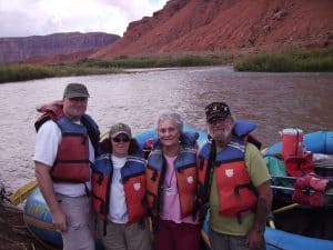 I steered us through pretty easily, though I could tell having a rookie at the helm made some of the other party members nervous. After one more set of rapids, she asked if anyone else wanted to try. No one did, so she took back over. The scenery was amazing. When we got to the pick up point, we stopped for group pictures.
That night at dinner, mom shared with us that dad had been nervous about the whole “white water” trip. Dad looked a little embarrassed, but smiled. Frankly, I don’t recall him ever being nervous, and he and I did some amazing and adventurous things at Philmont Scout Ranch. Dad chuckled a bit, told us he had been dreading it. He had the image of class V rapids in his head. He also said he had told mom as we were leaving the river and getting on the bus that he wouldn’t mind doing it again (and next time, he might even volunteer to “drive”.
The next morning, we packed up and got on the bus, heading to Cortez, CO. On the itinerary is Four Corners and Mesa Verde National Park.
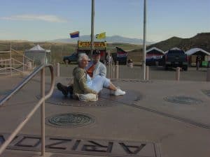 The Four Corners is a region of the United States consisting of the southwestern corner of Colorado, southeastern corner of Utah, northeastern corner of Arizona, and northwestern corner of New Mexico. The Four Corners area is named after the quadripoint at the intersection of approximately 37° north latitude with 109° 03′ west longitude, where the boundaries of the four states meet, and are marked by the Four Corners Monument. It is the only location in the United States where four states meet. Most of the Four Corners region belongs to semi-autonomous Native American nations, the largest of which is the Navajo Nation, followed by Hopi, Ute, and Zuni tribal reserves and nations. The Four Corners region is part of a larger region known as the Colorado Plateau and is mostly rural, rugged, and arid.
Four Corners is a place where you can honestly say you are in all four states at the same time. There were many vendors, selling trinkets, jewelry and food.
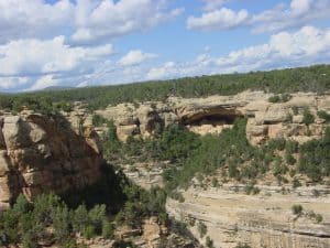 Back on the bus, we head to Mesa Verde National Park. It is a hidden gem. Okay, not hidden as it is very touristy, but hidden in the fact that the canyon is not always visible. You could drive (or ride a horse) right past this if you are not looking for it.
Not only was this defensible by not being seen, but the Pueblos hidden in the cliffs had some added defense due to their location embedded into the cliffs.
Mesa Verde National Park is an American national park and UNESCO World Heritage Site located in Montezuma County, Colorado. It protects some of the best preserved Ancestral Puebloan archaeological sites in the United States.
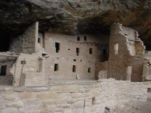 Created by President Theodore Roosevelt in 1906, the park occupies 52,485 acres (21,240 ha) near the Four Corners region of the American Southwest. With more than 4,300 sites, including 600 cliff dwellings, it is the largest archaeological preserve in the U.S. Mesa Verde (Spanish for “green table”) is best known for structures such as Cliff Palace, thought to be the largest cliff dwelling in North America.
 Starting c. 7500 BCE, Mesa Verde was seasonally inhabited by a group of nomadic Paleo-Indians known as the Foothills Mountain Complex. The variety of projectile points found in the region indicates they were influenced by surrounding areas, including the Great Basin, the San Juan Basin, and the Rio Grande Valley. Later, Archaic people established semi-permanent rockshelters in and around the mesa. By 1000 BCE, the Basketmaker culture emerged from the local Archaic population, and by 750 CE the Ancestral Puebloans had developed from the Basketmaker culture.
The Mesa Verdeans survived using a combination of hunting, gathering, and subsistence farming of crops such as corn, beans, and squash. They built the mesa’s first pueblos sometime after 650, and by the end of the 12th century, they began to construct the massive cliff dwellings for which the park is best known. By 1285, following a period of social and environmental instability driven by a series of severe and prolonged droughts, they abandoned the area and moved south to locations in Arizona and New Mexico, including Rio Chama, Pajarito Plateau, and Santa Fe.
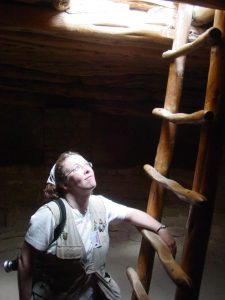
It was amazing to see and touch the history of the area. If you stopped and stared long enough, you could almost smell the cook fires, hear the children playing, and see the men and women adding to their culture through stories.
After several hours, we got back on the bus and went to our hotel in Cortez, CO. Tomorrow we will be heading to the first of our train rides, our Rails West.
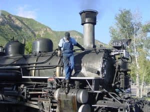
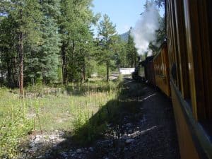
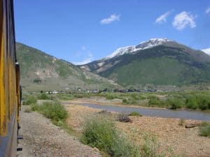
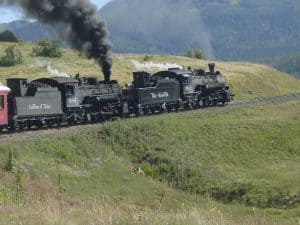
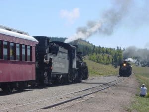
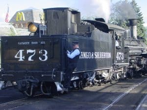 We headed to Durango and the train yard. This was the first of our Rails West train rides and would take us up into the Rocky Mountains to the historic town of Silverton. This historic steam engine still burned coal and was on a narrow gauge track. It was amazing to see this antique still working and the curators/engineers took good care of her.
The Durango & Silverton Narrow Gauge Railroad (D&SNG) is a 3 ft narrow-gauge heritage railroad that operates 45.2 miles of track between Durango and Silverton, in the U.S. state of Colorado. The railway is a federally designated National Historic Landmark and is also designated by the American Society of Civil Engineers as a Historic Civil Engineering Landmark.
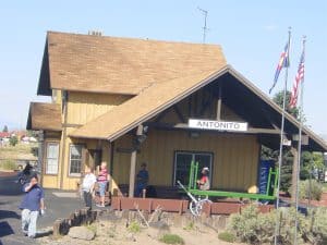
 The route was originally opened in 1882 by the Denver & Rio Grande Railway (D&RG) to transport silver and gold ore mined from the San Juan Mountains. The line was an extension of the D&RG 3 ft narrow-gauge line from Antonito, Colorado, to Durango. The last train to operate into Durango from the east was on December 6, 1968. The states of New Mexico and Colorado purchased 64 miles between Antonito and Chama, New Mexico, in 1970 and operates today as the Cumbres & Toltec Scenic Railroad.
The line from Durango to Silverton has run continuously since 1881, although it is now a tourist and heritage line hauling passengers, and is one of the few places in the U.S. which has seen continuous use of steam locomotives.
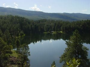
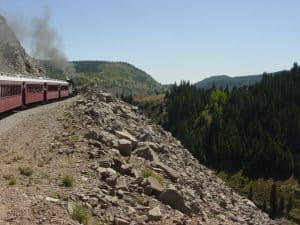
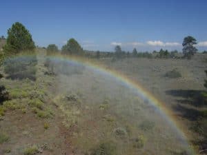
 The views of the mountain lakes, the rivers cascading down canyon walls, the towering trees and so much more made the vistas stunning.
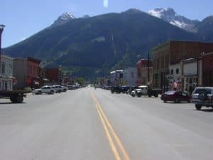 The ride brought us up to Silverton, an old mining town and in the winter a ski town where we toured and broke for lunch..
The town of Silverton is a Statutory Town that is the county seat of, and the only incorporated municipality in San Juan County, Colorado, United States. Silverton is a former silver mining camp, most or all of which is now included in a federally designated National Historic Landmark District, the Silverton Historic District.
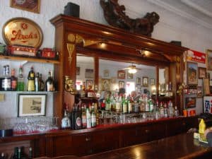 We ended up in an old bar for lunch. It was not quite what you picture old west bars or saloons to be, but was nice. Afterwards, we had some time to shop.
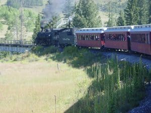 Our next ride on our Rails West tour, was on the Cumbres & Toltec Scenic Railroad took us high into the Rockies. The route was steep at several points, so steep that a second engine was needed to pull up the cars. It was easy to imagine riding this rail. It was not a commuter train, people did not take it daily to get from home to work and back. This, as with many of the rails moved people and cargo.
 The Cumbres & Toltec Scenic Railroad (C&TS) is a 3 ft narrow-gauge heritage railroad running for 64 miles between Antonito, Colorado and Chama, New Mexico. The railroad gets its name from two geographical features along the route, the 10,015 ft high Cumbres Pass and Toltec Gorge. Originally part of the Denver and Rio Grande Western Railroad’s narrow-gauge network, the line has been jointly owned by the states of Colorado and New Mexico since 1970.
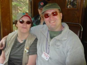
Mom and dad enjoyed the ride. One of the cars was open, like a flat bed with a rail. A word of warning, sunscreen is a good idea, but remember that it will pick up the coal suet given off by the train’s engine. You will be covered by the trips end. Still, it was well worth the trip.
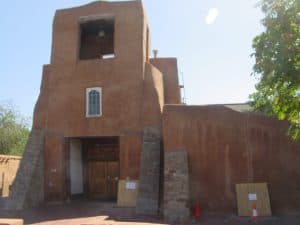
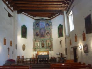
Our final stop was in historic Santa Fe, New Mexico. Key to the exploration and expansion of the west, Santa Fe was a key city in the route sharing its name, the Santa Fe Trail.
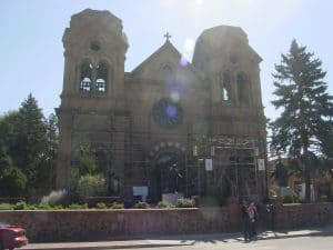
Santa Fe (Tewa: Ogha Po’oge, Navajo: Yootó) is the capital of the U.S. state of New Mexico. It is the fourth-largest city in the state and the seat of Santa Fe County.
 This area was occupied for at least several thousand years by indigenous peoples who built villages several hundred years ago, on the current site of the city. It was known by the Tewa inhabitants as Ogha Po’oge (“White Shell Water Place”).
 The city of Santa Fe, founded by Spanish colonists in 1610, is the oldest city in the state and the oldest state capital city in the United States. Santa Fe (meaning “holy faith” in Spanish) had a population of 69,204 in 2012. It is the principal city of a Metropolitan Statistical Area which encompasses all of Santa Fe County and is part of the larger Albuquerque–Santa Fe–Las Vegas combined statistical area. The city’s full name as founded remains La Villa Real de la Santa Fe de San Francisco de Asís (“The Royal Town of the Holy Faith of Saint Francis of Assisi”).
We had a wonderful farewell dinner. Tours are a good value, especially for those who like structure or need someone to help you plan. Sure a vacation planner can help you plan, it is up to you who you call or how you plan.